THE GLENMERRY TRAILHEAD has a small warming hut, where you sign in and pay if you are not a member, a well maintained outhouse and a large map outlining the entire trail network. Inside the hut, there are trail maps and membership enrollment forms as well as emergency information. There are numerous choices for intensity and skill and the same route skied in reverse is an entirely different experience.
GLENMERRY TRAIL: Provides access to the more challenging blue and black runs on the East side of the facility. Provides access to the connector runs that take you to the West side of the facility which has green and blue runs.
Difficulty: Intermediate-blue steady uphill. Downhill – very fast- control is important
Distance: 5.7 K to Glenmerry cabin
Elevation gain: 210 meters
Facilities: Glenmerry cabin: wood stove, seating, maps, first aid kit, emergency information, well maintained outhouse
Other: double track with packed middle
WINTERBERRY TRAIL: First trail that crosses Glenmerry. Turn right to access West side with green trails, turn left to access East side with more challenging trails
Difficulty: Intermediate-blue some rolling hills.
Distance: 4 K
Elevation gain: 20 meters
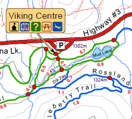
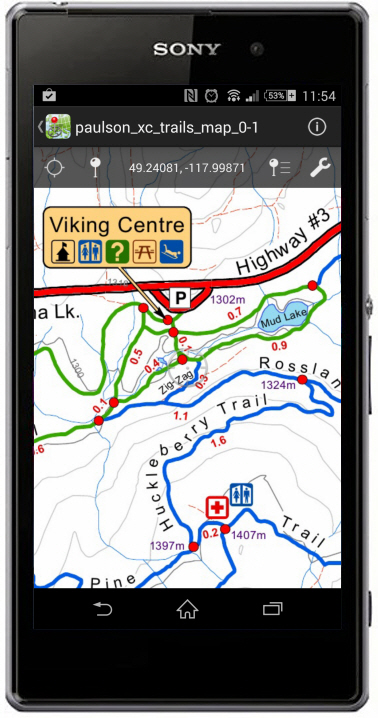
Facilities: West side leads to Mud Lake and the Viking Centre at the Mud Lake Trailhead. The Viking Centre is also a fee collection site, is a large cabin with wood stove, tables and benches, Maps, First Aid kit, Emergency information, two well maintained outhouses. There is a groomed toboggan hill with sleds available.
Other: single track with packed side. Popular with families with Viking Centre as a goal for a lunch stop and break before returning back to Glenmerry Trailhead.
LAMB TRAIL: Second trail that is accessed off Glenmerry to the left if going up. Access to East side
Difficulty: Black run, very steep, last trail groomed, short run, connects to Norwegian Trail
Distance: .4 K
Elevation gain: 60 meters
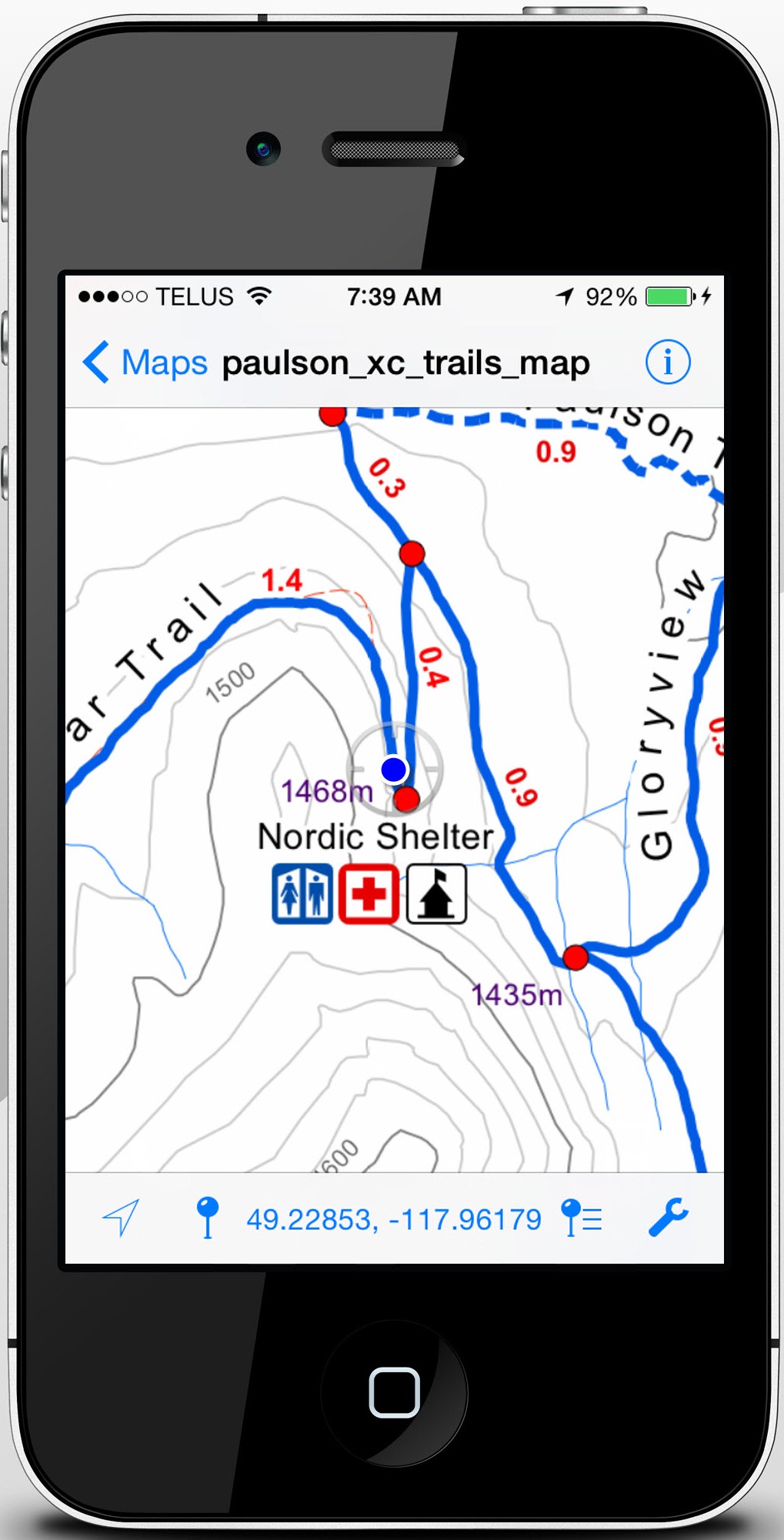
Facilities: Leads to Norwegian Trail to Ivar trail which accesses the Nordic cabin. Wood stove, seating, maps, first aid kit, emergency information and well maintained outhouse.
Other: never tracked, sometimes packed
ROSSLAND-PAULSON TRAIL: Third trail that crosses Glenmerry. Turn right to access West side, turn left to access East side with more challenging runs.
Difficulty: Intermediate-blue, rolling hills. If you turn left, you will be going mainly uphill to the East side. Right you will be going down for the most part
Distance: 4.8 K
Elevation gain: 100 meters
Facilities: West side leads to Mud Lake and the Viking Centre.
Other: single track, occasionally double track with packed centre. On the West side you can take the Connector which takes you to Winterberry giving you a short loop option back to Glenmerry or take Winterberry to Mud Lake and the Viking Centre, or take Roller Coaster direct to Mud Lake and the Viking Center.
PINE TRAIL: Fourth trail and mid point on Glenmerry Trail. Takes you to the West side, a more challenging run than Winterberry or Rossland-Paulson.
Difficulty: Intermediate -blue. Bottom portion can be more difficult and become a black run depending on snow conditions. Choose Huckleberry Trail, a solid blue run that connects to Pine and feeds into the Mud Lake area and the Viking Centre if you wish to avoid this challenge.
Distance: 4.8K
Elevation gain: If coming up from the West side 156 meters
Facilities: Our newest cabin, Snowberry shelter, is 2 k down Pine. Beautiful view, wood stove, seating, maps, first aid kit, emergency information and well maintained outhouse.
Other: single, sometimes double track with packed middle. Many choices to take other trails along Pine trail which offer green, blue and black experiences.
IVAR TRAIL: Fifth Trail off of Glenmerry and it accesses the East side.
Difficulty: Intermediate-blue. Rolling terrain. Steep hill at the cabin has a sharp turn that requires care and attention.
Distance: 1.8K
Elevation gain: 23 meters
Facilities: Nordic cabin with wood stove, seating, maps, first aid kit, emergency information and well maintained outhouse.
Other: single track with packed side. A good distance for a lunch stop and then you can connect to Norwegian for another loop up or connect with the Rossland-Paulson which you can extend and go to Mud Lake and the Viking Centre or turn off at Glenmerry and go back to the Glenmerry Trailhead.
NORWEGIAN TRAIL: Sixth and final trail off of Glenmerry. Glenmerry flows into Norwegian trail.
Difficulty: Blue/Black depending on conditions. Remote area, old growth trees with heavy snow loads can drop on trails and create challenging situations. Rolling steep hills both ways on this trail. One of the last trails packed so in heavy snows could be powder and you are breaking trail
Distance: 5.5 K
Elevation gain: 65 meters if coming up from Ivar or Glory view
Facilities: Glenmerry Cabin with wood stove, seating, maps, first aid kit, emergency information and well maintained outhouse.
Other: single track with packed side. Beautiful views if clear day. Choice at the bottom to take Glory view to Winterberry back to Glenmerry or Rossland Paulson to Glenmerry or Lamb to Glenmerry.
GLORY VIEW TRAIL: Can only be accessed from Norwegian or Winterberry. Very different experience up versus down.
Difficulty: Blue/black depending on conditions. Remote area, narrow trail, downhill can be very fast. Uphill is an intense work out. Several challenging steep hills and tight turns.
Distance: 3.2 K
Elevation gain: 153 meters if coming up
Facilities: feeds into Norwegian for Glenmerry cabin or Ivar for Nordic cabin
Other: single track with packed side. Beautiful view at the bottoms on Old Glory if it is a clear day.
THE MUDLAKE TRAILHEAD is where the Viking Centre, which is the main cabin, is located. The cabin is our largest with wood stove, tables and seating, first aid kit, maps and emergency information. Day user registration and fee collection takes place here. There are two well maintained outhouses. A groomed toboggan hill is located here with sleds available for use. Our three green runs are located here.
MUDLAKE LOOP: Flat packed and double tracked. A beautiful ski around the lake.
Difficulty: green-beginner. Flat
Distance: 1.7 K
Elevation gain: 0
Facilities: Loop is just off the Viking Centre
Other: Excellent track for multiple loops. Always packed first
BOOTY’S TRAIL: Mainly flat with some rolling hills. A choice of three loops. A short loop cutoff at the 1.7k mark and a mid loop cutoff at the 3k mark.
Difficulty: green-beginner
Distance: 3.9k one way
Elevation gain: 0
Facilities: Ben Shaw cabin is located at the end of the trail. Wood stove, seating, first aid kit, maps and emergency information
Other: double tracked with packed centre. Always packed first
BEN SHAW TRAIL: Mainly flat with some rolling hills. Booty’s Trail forms a loop with Ben Shaw back to the Viking Centre and is the run the short and mid loop cutoffs flow to.
Difficulty: green-beginner
Distance: 3.2k
Elevation gain: 0
Facilities: Ben Shaw cabin is at the start
Other: double tracked with packed centre. Always packed first. Pine, Seal Creek Road and Rossland-Paulson end at Ben Shaw which feeds back to the Viking Centre and back on Winterberry to the Glenmerry Trailhead.
HUCKLEBERRY TRAIL: Connects from Pine trail to Rossland-Paulson trail.
Difficulty: Blue-intermediate. Good workout coming out, fun fast run coming down
Distance: 1.6K
Elevation gain: 73 meters
Facilities: Connects onto Pine which leads to Snowberry Cabin
Other: double tracked and packed
SNOWBERRY TRAIL: Access is from the Snowberry cabin and connects with Pine and Old Growth Trail.
Difficulty: Intermediate-blue long rolling hills, gentle slopes. If going down the run, it ends in a steep black run
Distance: 2 K
Elevation gain: 18 meters
Facilities: Snowberry cabin is at the trailhead
Other: double tracked with packed centre. If going down this trail away from the cabin, you will end up with two options. Seal Creek Road which is a black run that is never packed or tracked or Old Growth Trail to Ridge Trail to Ben Shaw. Note: Ridge Trail is a short black run that is very fast and steep. This is a blue run that ends black and should only be taken by Advanced skiers. If you go up this route, it is an intense workout.
OLD GROWTH TRAIL: Connects Snowberry and Ridge Trail from Benshaw. Beautiful old growth Forrest.
Difficulty: Intermediate-blue, however ends or starts with Ridge trail which is a black run
Distance: 1.7 K
Elevation gain: 75 meters
Facilities: None
Other: double tracked with packed centre.
SEAL CREEK ROAD: Never packed, never tracked. Meets up with Ridge Trail, crossing Snowberry and Pine ending onto Ben Shaw trail
Difficulty: Black-Advanced
Distance: 6.1 K
Elevation gain: 172 meters
Facilities: Starts or ends at Ben Shaw cabin
Other: Entrance onto Ben Shaw is rough
RIDGE TRAIL: Starts or ends at Ben Shaw cabin. First section is packed, not tracked due to steep terrain. The remainder of the run is not packed or tracked. You can choose to take Old growth trail if you want a blue packed run or continue on Ridge. Ridge connects with Seal Creek Road.
Difficulty: Black-Advanced
Distance: 3.9 K
Elevation gain: 172 meters
Facilities: Starts or ends at Ben Shaw cabin
Other: Very challenging advanced skiers only
ZIG ZAG: Short trail connects the end of Rossland-Paulson on the west side to Mud Lake.
Difficulty: Blue-Intermediate
Distance: .3 K
Elevation gain: 0
Facilities: Access to the Viking Centre
Other: single track and packed
ROLLER COASTER: Short trail connects Huckleberry to Rossland-Paulson to Mud Lake.
Difficulty: Blue-Intermediate
Distance: .5 K
Elevation gain: 19 meters
Facilities: Access to the Viking Centre
Other: single track and packed
CONNECTOR: Short trail that connects Rossland-Paulson to Winterberry
Difficulty: Blue-Intermediate
Distance: .8 K
Elevation gain: 11 meters
Facilities: none
Other: single track and packed. Purpose to create a loop back to the Glenmerry trailhead or down Winterberry to the Viking Centre.